| Sno |
Parameters |
Information |
| 1. |
Name of Panchayat(Block & District) |
Laribal, Tral, PULWAMA
|
| 2. |
Number of Villages |
03
|
| 3. |
Name of Villages |
1. Laribal
2. Kavil Shikargah
|
| 4. |
Sarpanch Name and Photograph |
Nil

|
| 5. |
Sarpanch Mobile No |
00000
|
| 6. |
Panchs Name |
Harmeet Singh,
Farooq Ahmad Ganie,
Dilshada tabassum,
|
| 7. |
List of govt. officials |
Dilshada tabassum,
Dilshada tabassum,
|
| 8. |
Latitude/ Longitude |
33.54.13 N, 75.08.08.E
|
| 9. |
Area |
222.58 Hectares
|
| 10. |
Male (Population) |
758
|
| 11. |
Female (Population) |
751
|
| 12. |
Literacy rate |
50%
|
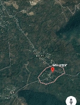
| 13. |
Map |
|
| 14. |
Topography |
Flat with Slight Slopy.
|
| 15. |
Major Water source of Irrigation |
Nothing
|
| 16. |
Water related govt. Schemes |
Lift irrigation Scheme.
|
| 17. |
Crops |
Apple, Maize, Rice, Walnut
|
| 18. |
Schools |
Government Schools
|
| 19. |
Angandwadi centers |
06
|
| 20. |
Status of Electrification |
Good
|
| 21. |
Status of piped water |
Good
|
| 22. |
Name of Police station |
Tral
|
| 23. |
Health Institutions |
Sub Centre Shikargah
|
| 24. |
Animal Husbandry |
Nil
|
| 25. |
Livestock�s |
Cattle, sheep,
|
| 26. |
No. of Self Help Groups |
01
|
| 27. |
Altitude above Sea Level |
1700 meters
|
| 28. |
Veterinary |
01
|
| 29. |
Specialty Crops etc. Natural Crops
|
Apple
|
| 30. |
Roads Connectivity |
Yes
|
| 31. |
Prominent Tourist/ Religion places in the Panchyat |
Shikargah
|
| 32. |
Distance from Nearest Headquater |
33 kms
|
| 33. |
PMAY Houses Approved |
Nil
|
| 34. |
PMAY Houses Completed |
Nil
|
| 35. |
No of House Holds |
246
|
| 36. |
No of House holds with toilets |
230
|
| 37. |
Does the Panchayat has its own Panchayat ghar |
No
|
| 38. |
Rented/Owned |
|
| 39. |
Geotagged Photo of Panchayat |
|
| 40. |
Geotagged Photo of Panchayat2 |
|
| 41. |
Uploaded Map |
|
