| Sno |
Parameters |
Information |
| 1. |
Name of Panchayat(Block & District) |
Teetwal, Teetwal, KUPWARA
|
| 2. |
Number of Villages |
2
|
| 3. |
Name of Villages |
Dringla byadi,Teetwal
|
| 4. |
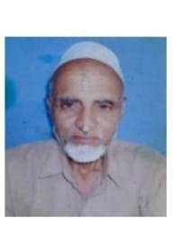
Sarpanch Name and Photograph |
Abdul Rashid Khoker
|
| 5. |
Sarpanch Mobile No |
9797848654
|
| 6. |
Panchs Name |
Younis Malik,
Fareed malik,
Mohd saleem ,
Mohd Sayeed,
Mohd Ismeel,
Jabeena Abas,
Naseer Ahmed,
Parveena Begum,
|
| 7. |
List of govt. officials |
Hakim Aqeb,
Abdul Rashid Khoker,
Zameer Hussain Shah,
Arshad Ahmed,
|
| 8. |
Latitude/ Longitude |
34.34.393221, 73.774217
|
| 9. |
Area |
386.5 Ha
|
| 10. |
Male (Population) |
1493
|
| 11. |
Female (Population) |
1357
|
| 12. |
Literacy rate |
62%
|
| 13. |
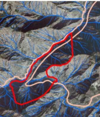
Map |
|
| 14. |
Topography |
Hilly
|
| 15. |
Major Water source of Irrigation |
Rain Fed,Minor Canal
|
| 16. |
Water related govt. Schemes |
........
|
| 17. |
Crops |
Wheat,Paddy,Maze,Vegitables,oat
|
| 18. |
Schools |
Hr Secondary, Middle School,Pry School
|
| 19. |
Angandwadi centers |
8
|
| 20. |
Status of Electrification |
99%
|
| 21. |
Status of piped water |
98%
|
| 22. |
Name of Police station |
Tangdar
|
| 23. |
Health Institutions |
PHC
|
| 24. |
Animal Husbandry |
1
|
| 25. |
Livestock�s |
.....
|
| 26. |
No. of Self Help Groups |
0
|
| 27. |
Altitude above Sea Level |
.....
|
| 28. |
Veterinary |
0
|
| 29. |
Specialty Crops etc. Natural Crops
|
.....
|
| 30. |
Roads Connectivity |
yes
|
| 31. |
Prominent Tourist/ Religion places in the Panchyat |
Border Tourism and kishan ganga view
|
| 32. |
Distance from Nearest Headquater |
93 Km
|
| 33. |
PMAY Houses Approved |
|
| 34. |
PMAY Houses Completed |
|
| 35. |
No of House Holds |
|
| 36. |
No of House holds with toilets |
|
| 37. |
Does the Panchayat has its own Panchayat ghar |
|
| 38. |
Rented/Owned |
|
| 39. |
Geotagged Photo of Panchayat |

|
| 40. |
Geotagged Photo of Panchayat2 |
|
| 41. |
Uploaded Map |
|
